I’ve combined Amy Johnson Crow’s 52 ancestors in 52 weeks challenge, and Steve Little’s The 2025 AI Genealogy Do-Over, to create a unique 52 AI ancestors in 52 weeks party!
52 AI Ancestors in 52 Weeks: Week 32 Wide open spaces
Introduction
This is a Public Service Announcement about researching at the United States Bureau of Land Management (BLM). There is no better use of the Wide Open Spaces topic if you’re in the US.
Discussion
What prompted me to think of this was a to-do list item which unfortunately was only in my head until now. Michael DOBBINS and his wife Mary MALONE were an Irish couple with several children. The family emigrated bit by bit during An Gorta Mór (The Great Hunger). They settled in Morris County, New Jersey for a time, where at least two daughters married and settled, and then the parents and younger children moved out to Shawnee, Wyandotte, Kansas, to farm. Numerous census schedules show Michael engaged in farming and with a considerable amount of land.
His will (Ancestry link; it’s restricted on FamilySearch) distributed much land:
- To my daughter Bridget Murphy: west half of South East (1/4) quarter of south west (1/4) quarter of section Eighteen (18) Town Eleven (11) Range Twenty five (25) containing twenty acres…
- To my son Michael Dobbins the west half (1/2) of north east quarter (1/4) of South West quarter (1/4) of section Eighteen (18) Township Eleven (11) Range Twenty five (25) containing twenty acres…
- To William Dobbins and James Dobbins the children of my [deceased] son James Dobbins the East half of South East quarter (1/4) of South West quarter (1/4) of Section (18) Eighteen, town Eleven (11) Range twenty five (25) containing twenty acres…
(Side note: Michael’s son James was killed in a duel in 1879.) I went back to the 1880 census, agricultural schedules (Ancestry link), and sure enough he has 58 acres improved and 2 acres unimproved, farm valued at $3,000.
What brought this poor Irish immigrant to Kansas? How did he end up with sixty acres of land? I suspect the answer for both questions is the same. I wonder if I might find answers at the Bureau of Land Management.
How AI can help
I went to Microsoft Researcher, and asked:
How do I use the Bureau of Land Management for genealogical research, if my ancestor unexpectedly got property in Kansas?
It gave me the chance to be more specific in my prompting ( 😊 ) so I replied:
My poor ancestor in New Jersey, Michael Dobbins, moved to Shawnee Township, Wyandotte, Kansas around 1865 and acquired 60 acres of property. How would he have been able to do this?
I added:
How would I be able to research any records that might exist around this grant or acquisition?
Microsoft Researcher was surprisingly thorough – AI gave me a to-do list I didn’t know I needed. It kindly provided me with a hefty output called Genealogical Research Report: Land Acquisition in 1860s Kansas (Case of Michael Dobbins). I’ll attach it at the bottom of this post. What it does (its thinking) is in the beginning, and the report starts on page 8. I think the list on page 11 is the meat of it:

This research is still on my to-do list (this was a big enough rabbit hole for today), but I now have a better idea what to do and where to go.
Challenge for Readers
Use Microsoft Researcher or Perplexity to suggest records for your specific situation: especially location and time frame and possible military service.
Want to Learn More?
A few resources:
- United States Land and Property (FamilySearch Wiki)
- Bureau of Land Management (BLM) Land Patent Search
https://glorecords.blm.gov
Search homestead and land patents in the public domain states. - National Archives – Land Records
https://www.archives.gov/research/land
Explains land entry case files, bounty land warrants, and homesteading. - U.S. Homestead Records (Fold3)
https://www.fold3.com/title/111/homestead-records
Digitized case files for several states (subscription needed). - Chronicling America (Library of Congress Newspapers)
https://chroniclingamerica.loc.gov
Use to find ancestor mentions, land auctions, or westward movement articles. - General Land Office (GLO) Maps
https://glorecords.blm.gov/details/maps/default.aspx
Survey maps showing property boundaries and terrain.
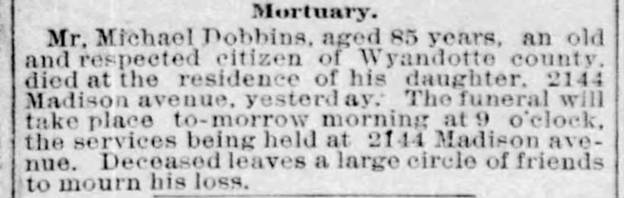
Here is Michael’s death notice; it says he “leaves a large circle of friends to mourn his loss”:
Next Week’s Topic: “Legal troubles”
AI Disclosure
This post was created by me with the help of AI tools. While AI helps organize research, the storytelling and discoveries are my own.
